
Peaks and Valleys of Pakistan: A 2026 Guide
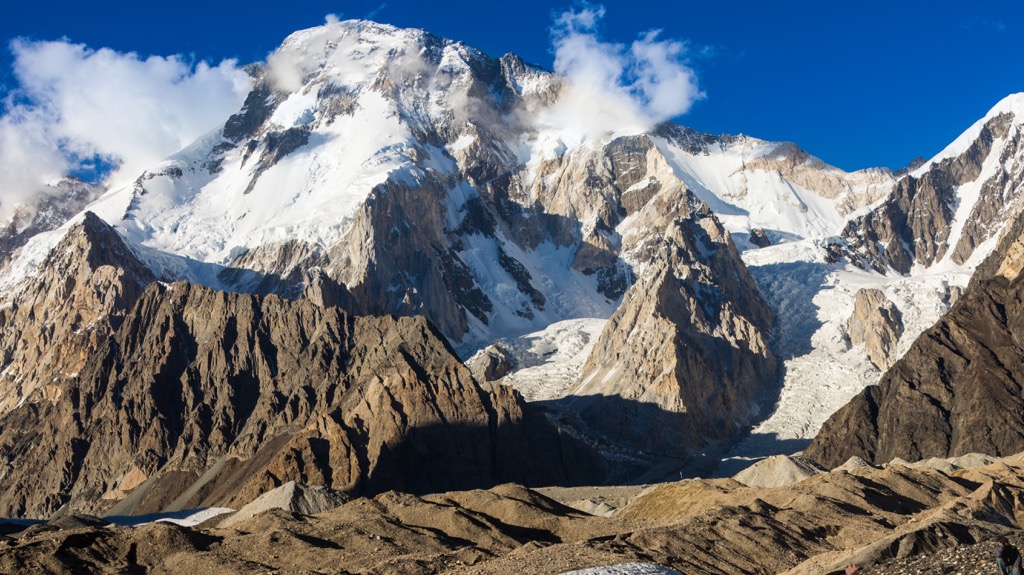
Pakistan has five peaks over 8,000 metres. Nepal has eight, and everybody knows their names. Almost nobody outside mountaineering can name Pakistan’s.
That gap is the whole opportunity. The Karakoram gets a fraction of the traffic the Himalaya sees, which means emptier trails, cheaper trips, and valleys where you are a curiosity rather than one of a queue.
Here is what is up there, and what it actually takes to go.
The peaks
K2, 8,611 metres
Second highest in the world and comfortably the hardest of the fourteen 8,000ers. Steeper than Everest, more technical, and far more exposed to weather that arrives without warning. The summit-to-fatality ratio has kept its reputation intact for seventy years.
You do not need to climb it to see it. The trek to K2 Base Camp along the Baltoro Glacier is one of the great walks on earth and needs no climbing skill, just fitness and about two weeks.
Nanga Parbat, 8,126 metres
Ninth highest globally, and the western anchor of the Himalaya. The Rupal Face on its southern side rises roughly 4,600 metres from base to summit, which makes it the highest mountain face in the world.
The nickname Killer Mountain comes from its early expedition history. For everyone else, the draw is Fairy Meadows, the alpine shelf directly opposite the peak, reachable by jeep track and an hour on foot.
Rakaposhi, 7,788 metres
Not the highest, arguably the most striking. Rakaposhi rises almost 6,000 metres straight out of the Hunza River valley with no intervening foothills, which is a rise you can see in one glance from the roadside. Very few mountains anywhere do that.
There is a viewpoint cafe on the Karakoram Highway near Nagar where you can drink tea and look straight up at it.
The rest of the Karakoram
- Broad Peak, 8,051 metres. Often paired with K2 in the same season since they share an approach.
- Gasherbrum I, 8,080 metres, and Gasherbrum II, 8,035 metres. Both in the same cluster at the head of the Baltoro.
- Trango Towers. Not tall by Karakoram standards but home to some of the largest sheer granite walls on the planet. This is big-wall rock climbing rather than mountaineering.
- Laila Peak, 6,096 metres. The scythe-shaped one you have seen photographed even if you did not know the name.
Those glaciers matter beyond climbing. The Karakoram feeds the Indus, and the Indus feeds the agriculture that most of Pakistan eats from.
The valleys
Hunza
The one most people mean when they say they want to see northern Pakistan. Hunza sits in Gilgit-Baltistan, ringed by Ultar Sar and the spire locals call Ladyfinger.
Karimabad is the base. Baltit Fort and Altit Fort are both restored and worth proper visits rather than quick photographs, Altit being the older of the two at roughly 1,100 years. Attabad Lake sits below on the Karakoram Highway, formed by a landslide in 2010 that dammed the river and drowned several villages.
Go in April for blossom or October for the colour. Those two windows are why photographers keep coming back.
Swat
Over in Khyber Pakhtunkhwa, greener and lower than the Karakoram valleys, and reachable year-round when the far north closes. Kalam and Malam Jabba carry the tourist traffic, Mahodand Lake is the day trip everyone does, and the valley holds serious Gandhara-period Buddhist archaeology that most visitors walk straight past.
Swat also gets extremely busy on public holidays. Our full Swat Valley guide covers the crowding problem and how to plan around it, and you can browse Swat listings on Traventigo for places to stay.
Neelum
A long crescent valley in Azad Jammu and Kashmir, following the Neelum River through forest and terraced villages. Sharda, Kel and Arang Kel are the names to know, Arang Kel being a meadow village above the valley floor reached by chairlift and a climb.
Practical caveat worth stating plainly: Neelum runs close to the Line of Control. Conditions can change, mobile coverage is patchy, and you should check the current situation before committing rather than assuming last season’s advice holds.
Kaghan and Naran
In Mansehra District, and the most accessible mountain valley from Islamabad. Lake Saif-ul-Malook above Naran is the famous one, at about 3,224 metres, with a folk legend attached that every guide will tell you.
Babusar Top, the pass linking Kaghan to Chilas at roughly 4,173 metres, is one of the best drives in the country and is usually open from around July to September.
Monsoon warning applies here more than anywhere: July and August bring landslides and flash floods to this valley specifically.
Skardu and the Shigar side
Skardu is the gateway to everything Baltoro. Shigar Fort has been restored into a heritage hotel, the Katpana cold desert sits at over 2,000 metres with actual sand dunes against snow peaks, and Deosai National Park spreads across a plateau at around 4,100 metres.
Deosai is only open roughly late June to September. Outside that it is under snow.
Permits: the part most guides skip
This is where trips fall apart, and almost no listicle covers it.
What needs a permit
- Any peak above 6,500 metres requires a permit from the Gilgit-Baltistan Council, regardless of whether it sits in an open or restricted zone.
- Restricted-area treks require a trekking permit.
- Open areas of Gilgit-Baltistan need no trekking permit at all. This covers most ordinary tourism, including Hunza, Skardu town and the Karakoram Highway.
So if you are visiting valleys, driving the KKH and walking day hikes, you almost certainly need nothing beyond your visa.
How the process works
Foreign climbers cannot apply directly. Applications must go through a tour operator registered with Pakistan’s Directorate of Tourist Services, who submits to the Gilgit-Baltistan Council Secretariat along with member insurance, liaison officer arrangements and porter insurance.
Budget four to six weeks for clearance. Combined with the new e-Visa timeline, that means an expedition needs planning months ahead, not weeks.
What it costs, honestly
Here the reporting genuinely conflicts, and you should know that before you budget.
Gilgit-Baltistan announced a large increase in late 2024 that would have moved K2 to individual permits at several times the previous per-head rate. That was challenged and reported as frozen. Since then, one set of figures circulated putting K2 summer permits around 3,500 US dollars, while reporting in May 2026 put the summer rate at 5,000 dollars, autumn at 2,500 and winter at 1,500, with separate and much lower rupee rates for Pakistani climbers.
Treat every number you read online, including these, as indicative only. Fees are set annually and have moved repeatedly in both directions. Confirm current rates with a licensed operator before you commit to anything.
Two costs that are consistent across sources: expeditions inside Central Karakoram National Park pay a separate environmental and waste management fee per member, and winter climbing attracts significant discounts.
When to go
- Hunza and Gilgit: April to October, with April blossom and October colour as the two standouts.
- Skardu and the Baltoro: June to September. The trekking season is genuinely narrow.
- Fairy Meadows: late June to August only.
- Deosai: late June to September, snowbound otherwise.
- Babusar Top: roughly July to September.
- Kaghan, Naran and Neelum: summer, but expect monsoon disruption in July and August.
- Swat and Murree: viable through winter, which is their real advantage.
If you want one recommendation: late September into October. Roads are still open, the monsoon has passed, domestic crowds have gone home and the valleys turn.
The honest problems
Two things are changing these mountains, and a guide that skips them is not being straight with you.
Glacial melt. The Karakoram holds some of the largest glaciers outside the poles, and they are retreating. That shifts water supply for the whole Indus basin and raises the risk of glacial lake outburst floods in the valleys directly below.
Tourism pressure. Domestic tourism has grown far faster than the infrastructure to handle it. Waste management in Hunza, Swat and Naran has not kept pace, and the trekking corridors carry litter that nobody is funded to remove.
What you can do about it is unglamorous but real: carry your rubbish out, use local guides and locally owned accommodation, and avoid single-use plastic where the disposal chain simply does not exist.
Deosai and Khunjerab National Parks exist partly to hold the line on this, and community-run conservation in Hunza has had genuine success with snow leopard protection.
Frequently asked questions
How many 8,000 metre peaks does Pakistan have?
Five: K2 at 8,611 metres, Nanga Parbat at 8,126, Gasherbrum I at 8,080, Broad Peak at 8,051 and Gasherbrum II at 8,035. Four of the five sit in the Karakoram, with Nanga Parbat in the western Himalaya.
Do I need a permit to visit Hunza or Skardu?
No. Open areas of Gilgit-Baltistan, which include Hunza, Skardu and the Karakoram Highway, require no trekking permit. Permits apply to restricted-zone treks and to any peak above 6,500 metres.
Can a normal hiker trek to K2 Base Camp?
Yes. The Baltoro trek requires no technical climbing, though it does demand solid fitness, altitude tolerance and around two weeks. It must be arranged through a licensed operator.
Which is the most beautiful valley in Pakistan?
Hunza takes most votes for the combination of mountain scenery, restored forts and accessibility. Neelum and Kaghan are greener and more forested, while Skardu offers the most dramatic high-altitude landscape.
What is the best month for northern Pakistan?
Late September or October. Clear skies, no monsoon, thinner crowds and autumn colour through the valleys. April is the alternative if you want blossom in Hunza.
Worth the paperwork
Pakistan asks more of visitors than the Nepal circuit does. The permits are slower, the roads are less forgiving, and the tourism machinery is thinner.
What you get back is a Karakoram that has not been packaged. You can stand under an 8,000 metre peak with almost nobody else there, which is no longer true of most of the Himalaya.
Plan early, go in autumn, and hire local.
More on the region: our guide to the most visited tourist places in Pakistan covers visas and costs, and free and low-cost places to visit is worth reading if you are on a budget.
Related articles
Wanderlust Chronicles: Exploring Hidden Gems Around the World
Wanderlust Chronicles In an age where popular travel destinations are often overcrowded and overexposed, more travelers are turning their attention to the road less…
Read article
Pakistan’s Free or Low-Cost Traveling and Visiting Points
Introduction Pakistan, with its diverse landscapes, ancient heritage, and rich culture, is one of the most beautiful yet underrated tourist destinations in the world.…
Read article
Top Tourist Attractions in Sindh You Must Visit (2026)
Sindh gets skipped. Most itineraries land in Karachi, spend two days, then fly north to the mountains. That is a mistake. This province holds…
Read article